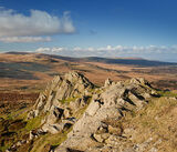
Mynydd Preseli - Pembrokeshire
The range stretches from the proximity of Newport in the west to Crymych in the east, some 13 miles (21 km) in extent.
The highest point at 1,759 feet is Foel Cwmcerwyn. The ancient 8 miles (13 km) of track along the top of the range is known as the Golden Road.
The highest point at 1,759 feet is Foel Cwmcerwyn. The ancient 8 miles (13 km) of track along the top of the range is known as the Golden Road.

Foel Eryr - Cairn / Barrow

Cerrig Lladron - Stone Row

Slate Quarry

Tafarn y Bwlch - standing stones

Waun Mawn - Standing Stone

Foel Cwmcerwyn

Foel Feddau

View

Winter Scene

Carnau Lladron

Cerrigmarchogion

One of the Cerrigmarchogion carns

Panorama - Preseli Peak

Carn Goedog

Carn Bica

Beddarthur - (Arthur's Grave)

Carn Arthur

Carn Arthur - Perched Boulder

Bluestone Monument

The Waldo Bluestone

"Gors Fawr" - Stone Circle

"Gors Fawr" - Stone Circle

Standing Stones

Cerrig Meibion Arthur - Standing Stones

W R Evans - Bluestone Monument

Maen-Y-Parc - Standing Stone

Carn Alw - Chevaux De Frise

Carn Alw - Rhyolite with Flow Banding

Carn Alw

Carn Ddafad-las

Rocky Carns

Carn Menyn , Cairn - Chambered Tomb

Carn Menyn

Carn Menyn - " Butter Rock ".

Carn Menyn

Sheepfold

Foeldrygarn

Foeldrygarn

Winter Scene

Foeldrygarn

Preseli in winter

Bronze Age Cairn

Foeldrygarn Cairns

Mynydd Preseli Summit

Pentre Ifan

Sundew / Brynberian Moor

Cotton Grass
Maiden Castle

